
Page 49 - 2020년김해시통계연보
P. 49
Land and Climate 47
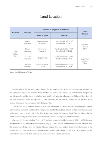
Land Location
Extreme of longitude and latitude
Gross
Location Extremity
distance
Name of place Extreme
Eastern Daedong-myeon East longitude 129˚ 0' 48"
extremity Wolchon-ri North latitude 35˚ 16'16"
East-West
distance
Western Jinyeong-eup East longitude 128˚ 41' 47" 27km
extremity jwagon-ri North latitude 35˚18'12"
2401,
Gimhae-
daero
Southern East longitude 128˚ 49' 44"
extremity Jangyu-dong North latitude 35˚ 9'10" South-North
distance
32km
Northern Saengnim-myeon East longitude 128˚ 51' 59"
extremity Doyo-ri North latitude 35˚ 23'31"
Source : Land Information Division
Our city is located in the southeastern district of Gyeongsangnam-do, Korea, and the mountainous district of
the Sobaek is located in the northern district and thus has a small sized plains. It is contacted with Yangsan city
and Miryang City and the forms the Gimhae plain widely, following the tributary to the Nakdong River in south
and east, and adjoins Busan Metropolitan City, and Mt.Bulmo(801.7m) and Mt.Gulan(651m) are spreaded in the
western district, and also is contacted with Changwon City.
There is Nam Hae Highway form east to west, centering around the downtown, and the Gyeongjeon Railway
is located west and north, and this city is contiguous to Gimhae International Airport, and thus has the convenient
traffic system, and the royal tomb of the King of Suro which is the forefather of Garak Kingdom is located in the
center of downtown, and the Guji Peak and the ancient tomb of Gaya Ages are widely spreaded.
Also, our city became Gimhae-Gun in 1895 and then promoted to Gimhae-eup in 1931, and Gimhae-eup
was promoted to the administrative zone of City on July 1, 1981 and the administrative zone was different even
if it was the same living circle, but Gimhae City and Gimhae-Gun were unified, based on the law related to the
establishment of Urban and Rural Combination-Typed City (No.4948) on May 10,1995 and thus reverts to the
administrative zone before 1981 and thus reaches to the current administrative zone.